Map of Sinai showing Exodus routes
Click on Add map to cart button below shopping cart.
Purchased Maps do not have watermarks, are high resolution (150dpi) & have crisp, clear labels/town names.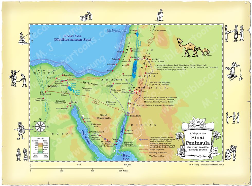
Bible Book: Exodus
Bible Book Code: 0201203701a
Bible Reference & Map Description
This is my map of the Sinai Peninsula, showing two possible routes of the Hebrew people during the Exodus from their captivity in Egypt. The purple dashed line shows the more traditional interpretation, passing through the Red Sea at the head of the Gulf of Suez. The white dotted line shows one alternative route, where Bible scholars infer that the Hebrew people crossed the Red Sea at the mouth of the Gulf of Aqaba.
There are many place names and locations on the route (which ever one was actually taken!) which are lost to antiquity, so I can not be certain of some of the places the Hebrew people camped at on their 40 year journey to the promised land.
Date
The Exodus from Egypt occured around 1446 B.C.
Notice the figures on the border of the map.
If you look carefully at the map border you will see I have included some little black and white figures. I will add different figures to the borders of each map, adding characters that relate to the map subject.
Link(s) to related Bible Cartoons
Click orange bars below to see the Bible Cartoons that relate to the Exodus of the Hebrew people from Egypt, on the BC Gallery page, with download & purchase options:
Bible Cartoon: Exodus 12 – The Exodus begins – Scene 05 – Walking
Bible References
The Exodus is covered in detail in the Bible book of that name. A shorter overview of the camp locations made by the Hebrew people is written in Numbers chapter 33.