Maps of the walls of Jerusalem rebuilt by Nehemiah.
Posted 20 Mar 2023
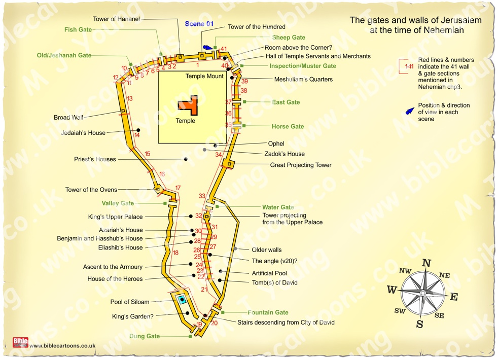
Map of the walls & gates of Jerusalem at the time of Nehemiah
The blue dot & arrow on the map shows the position of the viewer & their direction of view in the various scenes you can find in Nehemiah chp 3.
I have spent much of today creating a plan map of the walls of Jerusalem when Nehemiah returned from exile in Babylon, specifically to rebuild the walls which had been largely pulled down 70 years earlier. I think that was about 444 B.C.
It has been quite difficult to create the map, as the exact size & position of the walls relative to each other is quite hard to determine from the various articles I have read. I have looked at other maps available in Bible atlases, books, etc, but many of the wall features are described in very different ways. For instance the Broad Wall (Nehemiah 3:8) was built by Hezekiah (king) but some maps show that wall at right angles to the existing walls (& encircling the newer, western part of the city), whilst some show it as part of the main walls themselves.
The position of the gates is something of a mystery too! We can’t look at the walls & gates of Jerusalem as they stand today, because they were built between 1535 and 1538, when Jerusalem was part of the Ottoman Empire, by Suleiman I! Many of the gates mentioned in Nehemiah are probably below the current ground level.
The descriptions of the gates & walls in encyclopaedias, books, etc always seem to start with the North Eastern Sheep Gate, & proceed in an anticlockwise direction, going round the walls, & ending up back at the Sheep Gate. That is how Nehemiah described the walls, so if it’s good enough for him, I guess it’s good enough for the rest of us too!
I have drawn a map based on some others I have seen, & using the features mentioned in Nehemaih chp 3. Where I am uncertain of a feature I tend to put a “?” after the name. I have divided the wall up into 41 different, adjacent sections, based on the descriptions in Nehemaih chp 3, numbered 1-41, & with red lines to denote the approximate length & relative position of the section mentioned in Nehemiah’s description. I will be creating 41 scenes & 41 maps, one for each of the sections discussed by Nehemiah.
You can see that I am adding a little blue dot & triangle arrow to the maps, which shows where the viewer ( of each individual scene) is standing, & in what direction they are looking in. I am hopeful this will help viewers of the scenes to orientate themselves when they flick from scene to scene.
My intention is to draw all 41 sections of the walls, all the way around Jerusalem. This will take me some considerable time to achieve! My idea is to draw the first sections with very low walls, representing the start of the work, and as we go around the walls, I will show them at various stages, increasing in height/completion. When we are about a quarter of the way round, I will show the walls & gates a quarter finished. When we are half way round the walls (somewhere near the Dung or Fountain gates) I will show the walls & gates half finished. And when we near the Sheep gate again (at the end of the circuit around the walls), I will illustrate the walls & gates much higher & closer to completion.
Comments
Comments are turned off for this article
Go to Blog Archive page